One of the fundamental requirements of a market analysis is the ability to understand the economics of the location. To fully understand the value that a property in its current or planned use brings to a market, one must consider the economics of urban growth patterns as well as the overall market activity and health of the area.
Both the current value and forecasted trends in rent, property value, and vacancy depend upon an understanding of how cities grow and how those urban development trends ultimately influence real estate values throughout the city. Of course, cities can grow in many ways, and understanding the patterns of urban growth can help clarify the big picture in a real estate analysis. In this post, we’ll discuss several different urban growth models that are commonly used to explain the growth patterns of cities.
Concentric Circle Growth in Urban Development
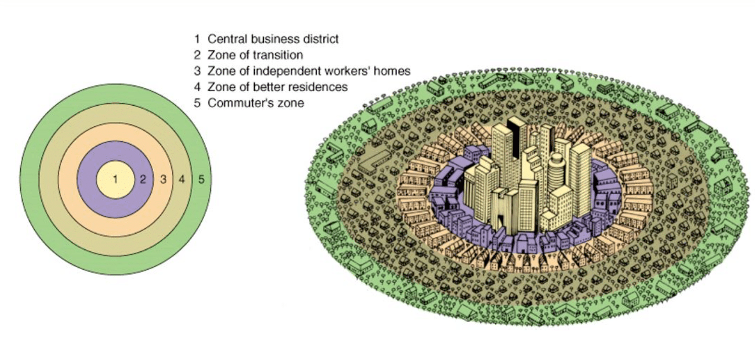
The concentric circle growth model, or CCD model, was one of the first theoretical models of urban development. A sociologist named Ernest Burgess first developed this model in 1925. The urban development patterns in Chicago were the inspiration for the concentric circle growth model.
Concentric circle growth starts with a central business district at the heart of the city. Everything grows up around this central hub of economic activity for the city. The concentric circle growth model is an application of bid-rent theory. Those who can pay the highest rents are located near the economic hub of the central business district. Real estate prices are lower as you move away from the central business district, but then people also need to consider transportation time and costs to get to work in the central business district. Although widespread car ownership led to the development of business activity outside the central business district, the basic idea of this model still holds true in large urban areas. It is also important to note, however, that topography and geography can prohibit growth of the concentric circles in a given direction. For example, Chicago’s growth is limited to the east because of Lake Michigan. Mountains, oceans, and large rivers can also limit growth in a particular direction.

The first zone in the concentric circle growth model is the city’s central business district. This is the area that is the center of economic activity in the city, and most people work in this zone. The land here has the highest value and earns the highest economic returns. Much of the development in this area is in the form of high-rise office buildings and skyscrapers, necessary to meet the needs of a high population density. The availability of residential property in this zone is highly limited due to the exceptionally high cost of real estate. As a result, luxury apartments serve the wealthiest segment of the population. Another component of the central business district is its easy accessibility with highways and public transportation.
The second zone is a transition zone where offices turn into factories. At least, this is traditionally where industrial activity took place, right outside the major financial hub of the city center. The housing that developed in this area was low-cost tenement housing meant for factory workers. Today, this area still includes factories, industrial warehouses, and transportation hubs. Most of these areas, however, have been redeveloped into mixed-use properties that are part of urban revitalization projects. Redevelopment in these areas has created unique neighborhoods featuring a mix of commercial and residential real estate. Prices per square foot in this zone tend to be relatively high (though not compared to the central business district), so both residential and commercial spaces are small.
The third zone is traditionally a residential area. It is considered to be a sort of inner suburban area that was traditionally an area for working-class residents. The homes were of decent quality, and many factory workers lived in this area. Those who lived in the transition zone desired to one day have enough money to move into this area. Today, some of these areas have fallen into considerable disrepair and are subject to considerable amounts of crime and low property values. On the other hand, many cities have invested money in renovating and redeveloping these neighborhoods into desirable and thriving communities for young urban professionals and their families. Areas that have successfully redeveloping neighborhoods in this zone are currently experiencing high growth in property values. The proximity to the central business district as well as entertainment venues are highly desirable to the younger population segment willing to trade more square footage for a shorter commute time.
The fourth zone is another residential area occupied by white-collar workers. Homes in this area are considerably larger and newer developments. There are detached, single-family homes in the outer suburban zone. In addition, there are many amenities such as parks, shopping centers, and restaurants. Residents in this area are more likely to start small businesses. Schools in this zone also tend to be of significantly higher quality than those in zone three. This is another driving factor for higher property values and population growth.
The fifth zone is the outermost zone and referred to as the commuter zone. Middle class and upper class families who desired even bigger home and more open space traditionally resided in these areas. The commuter zone also had the benefits of parks and shopping centers, but these areas tend to be more spread out than they are in the fourth zone. There is also a considerable amount of undeveloped land still available in this zone. Transportation access is key to residents in the commuter zone. The residents residing in this area need to be wealthy enough to afford the big house as well as the time and expense of commuting into the central business district every day. Since there is considerable cost associated with the commute, this zone tended to be reserved for wealthier families desiring a quiet life outside the city.
As automobile transportation became widespread in the United States, the assumptions of this model tended to change. Smaller versions of the central business district started to grow inside some of the outer zones, and the factories in the transition zone closed. Technology replaced manufacturing, and urban development patterns changed along with them. In addition, the boundaries between zones are more fluid than the descriptions may indicate. Still, looking at the urban development patterns from a distance, the transition from central business district through commuter zone is visible.
Three other theories of urban growth were later developed as variations of the concentric circle model of urban development.
Axial Growth
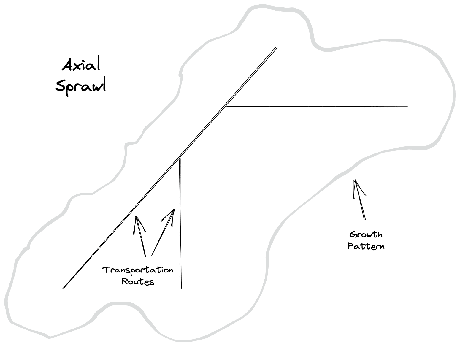
Historically, transportation was one of the critical factors in determining where cities developed. Cities often grew up around key port locations, as well as railway and highway hubs. The ease of accessibility became a comparative advantage for these locations. The axial growth model was developed in the 1930s and suggests that development occurs along the transportation lines leading out of the city center.

Commercial and residential property first begins next to these transportation lines as they move away from the city center. Then, development starts to spread away from those transportation lines. Although the development of beltway-type highway systems around major cities has reduced some of this axial development, the fundamentals of this theory can be observed across the country. Locations near major roads through town or highways through a state have value for both residential and commercial properties. Being located near these major transportation arteries reduces travel time and provides ease of access to the location. Traveling away from a major transportation route results in less development and lower real estate prices.
Sector Growth
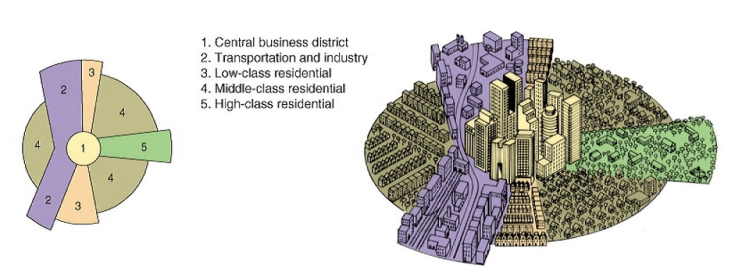
In the 1930s, Homer Hoyt published another variation of the concentric circle growth model called the sector growth model. The sector model recognized that growth tends to extend outward from the city center primarily along transportation lines and that specific types of development tend to cluster together in patterns. Many European cities, particularly British cities, exhibit this development pattern.

In the sector growth model, manufacturing and residential areas don’t develop as concentric circles, but instead as wedges outward from the central business district. The industrial or manufacturing sector is usually located along a major industrial rail line or river through the city. There may also be some very low price residential real estate where only the lowest classes of citizens live. This is an undesirable residential region due to its proximity to the factories. The third sector is low-class residential, with small houses built close to each other. This sector is a more desirable area for factory workers because the living conditions are better, but it is still in proximity to their workplace. The majority of the area around the central business district is the middle-class residential sector. Some of these residents may work in factories, but most work in the central business district and can afford nicer homes and a longer commute. Homes in this sector are larger and further apart than in the low-class residential sector. The smallest sector moving away from the central business district is the high-class residential sector. This sector has the least traffic, the most open space, and the largest homes.
Most people’s experience will confirm the sector growth model. While not perfectly accurate, it’s likely that in your own hometown, you will be able to identify various sectors that follow this growth model.
Multiple Nuclei Growth
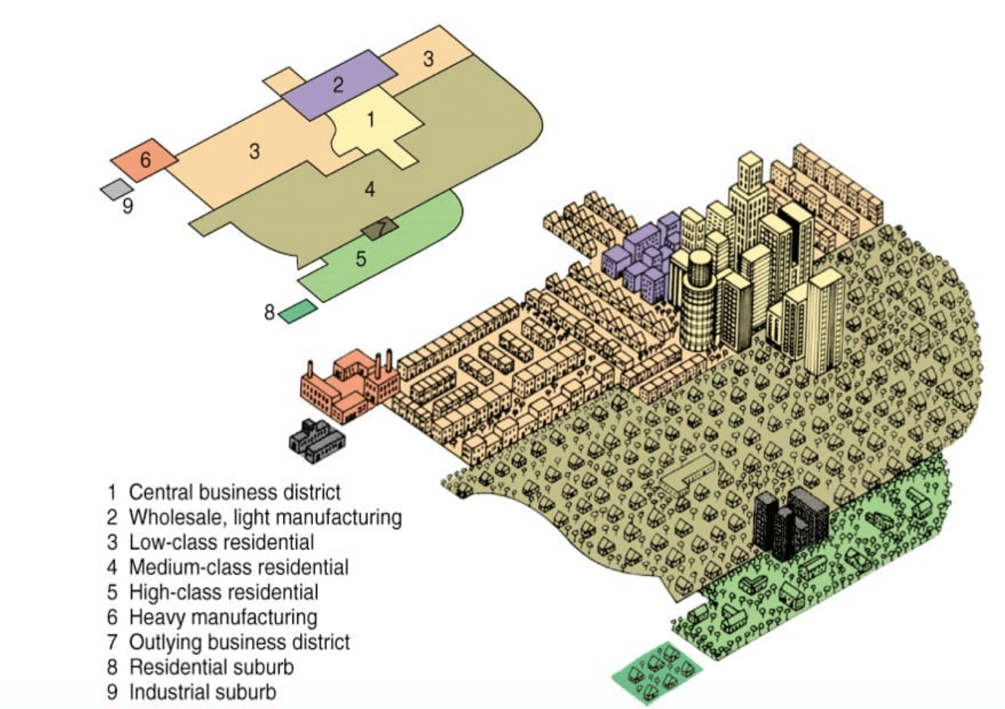
As cities grew and expanded their boundaries outward, the model of the city began to change in some places. Cities became more complex in their design, and new areas of business activity emerged. In 1945, C.D. Harris and Edward Ullman published a model that attempted to explain the new complex shape of urban development. While rail transportation was at the center of previous models of urban growth, the multiple nuclei growth model considered the new disruptive technology of automobile transportation.
The multiple nuclei model recognizes that commercial activities occur in clusters, and for many cities there is more than one center of activity. In fact, most cities have become fragmented over the past few decades and have experienced a deterioration in central business district importance relative to suburban office parks and shopping centers. This has caused many communities to create “Save Downtown” plans and campaigns.
The multiple nuclei growth model suggests that new clusters grew for a variety of reasons. Certain activities require specialized facilities. Many similar activities benefit from being located near one another because they create synergies, but certain dissimilar activities are detrimental to one another. Finally, some activities require low-cost, less desirable locations.

The multiple nuclei model retains some of the same fundamental factors contained in both the concentric circle growth model and the sector growth model. The city still develops around a central business district that contains high-rise commercial development to maximize the use of the real estate. Outside the central business district is a light manufacturing or warehouse sector. The multiple nuclei model introduces a heavy manufacturing zone, which is located a considerable distance away from the central business district. There are no residential properties in the heavy manufacturing zone, but the low-class residential zone connects the two manufacturing areas of the city. This area contains apartments and small homes built close together. There may also be a smaller, industrial suburb located a short distance from the heavy manufacturing zone. Extending from the central business district in the other direction, the middle-class residential zone is the largest section of the city. The homes here are medium-sized and further apart. Due to the large number of people living in this area, new business activity slowly developed in this region. As a result, the multiple nuclei model included a new outlying business district between the middle-class and high-class residential zones. In addition, new residential suburbs may develop outside this area.
Conclusion
In this article, we discussed several urban growth models that describe how cities grow. First, the concentric circle model recognized that most cities tend to grow outward circularly from the central business district. This was because transportation between cities was mainly by rail, which caused manufacturing activity to locate around the downtown rail station. This resulted in other land uses developing in a circular pattern around the central hub in concentric circles. Later, this growth pattern broke down and in the 1930s the sector growth model was created. It found that growth tended to happen in wedges that cut across the original rings. This happened because the city’s internal transportation networks made it easier for companies to distribute goods. Around the same time, the axial growth model was created and recognized the impact of mass transportation to show that cities tended to grow along major transportation routes. Finally, the multiple nuclei model of growth emphasized that activities in a city occur in clusters. It recognized the impact of suburban shopping centers and office parks and the decreased importance of the central business district.
Understanding the fundamental theory behind the concentric circle growth model and its variants remains important today when developing a market analysis. First, it is true that real estate values are often highest in the central business district or city center. Rent is usually highest in this area, and it is the hub of most economic and entertainment activity in a city. There are residential areas inside the central business district, but they are small and expensive compared to areas outside the central business district. In some cities, the demand for real estate in the central business district caused it to expand into neighboring zones, and all the other zones pushed outward in response.
Moving outside the central business district, there are either low-income areas with poor quality residences and little business activity or areas growing due to urban revitalization and gentrification efforts. Depending on the current condition, the market could experience declining values or significant growth opportunities for both commercial and residential properties. In general, these areas are highly desirable for young, urban professionals who like the hip city lifestyle but cannot afford to live in the heart of downtown.
Finally, as the boundaries of the commuter zone pushed out further and further over time, American cities experienced a phenomenon known as urban sprawl. Families wanting bigger homes, new developments, and more space continued to move away from the central business district. As a result, the suburbs and areas of suburban development extend far outside the city limits. The cost and time associated with the commute, however, seem to have hit a maximum in recent years. There is a new trend in which families are choosing to trade in their huge homes for smaller homes closer to the central business district. In other words, there is the beginning of a reversal in the trend that originally created the commuter zones and urban sprawl. As a result, development and growth in zones closer to the central business district can expect higher growth in future if this trend continues. Understanding where a location fits into this model and the corresponding rent and growth prospects is an important component to developing a market analysis.
